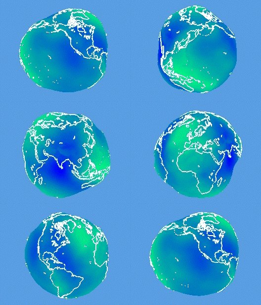
EGM08 in ECEF Technical software development
Geodesy and cartography
Seismic and subsea navigation
Ocean-bottom positioning
Inertial (IMU/INS) integration
3-D (ECEF) visualization

The scope of Hydrometronics' offerings was due to the long career of its principal (click on the 'about us' link above). Hydrometronics was primarily a Matlab ® shop, providing compiled, user-friendly, GUI-driven applications, .NET or C-language DLLs, or C source code that solve client problems in all the fields cited above, which are not exclusively nautical. Hydrometronics ceased business in 2021 though the website has been preserved.

In addition to software development, Hydrometronics consulted in all these fields, bringing a career of expertise to bear on your needs.

For a sampler of the disciplines addressed by Hydrometronics, visit the 'downloads' link above for papers presented over the years or visit the four heritage links below for extractions from those papers (preserved in place for the web bots).

EGM08 in ECEF (above)

Earth Gravitational Model 2008 (EGM08) is the best, world-wide, freely-available model of the geoid. Earth-Centered Earth-Fixed (ECEF) is the 3-D, orthogonal, geocentric, Cartesian, coordinate system used by GPS, which empowers distortion-free visualization. Geoidal undulations are exaggerated 10,000 times here for visual effect.

Some Hydrometronics Projects Were:

Links to heritage entertainments (see 'downloads' above for more):

The world is 3-D. Visualization environments (VEs) used nowadays in the geophysical industry are 3-D. Why suffer the distortions of a 2-D map projection entering real-world data into a VE? Earth-Centered Earth-Fixed (ECEF) and topocentric coordinates provide scalable visualization without distortion. (For the entire presentation click on the 'downloads' link above.)
Link=> Earth-centered earth-fixed and topocentric visualization
The Earth Gravitational Model 2008 (EGM2008) defines a level surface conterminous with mean sea level (geoid). In a 3-D ECEF world, which way is up? Or down? It is perpendicular to EGM2008 shown here in ECEF rotating about the Earth's spin axis.
Link=> Earth Gravitational Model 2008 in motion
For the faint of heart who need a 2-D map projection in their 3-D VE, the ellipsoidal orthographic projection is that. It's also a step from projected coordinates in the direction of topocentric and ECEF coordinates.
Link=> Orthographic projection
Is a 7-parameter datum shift more accurate than a 3-parameter datum shift? Perhaps, if derived over a large area. But if derived over a small area, high correlations will rob the derived parameters of physical significance. P7DOP (7-Parameter Dilution of Precision) quantifies just how bad it can get. For the entire Molodensky-Badekas presentation to the Americas Petroleum Survey Group click on the 'downloads' link above.
Link=> 7-Parameter Dilution of Precision